CLASSIC TREK: 3 DAYS, 15km
Mount Anne is the highest peak in South-West Tasmania and the rocky summit is on the bucket list of hikers from all around Australia. A major reason for this is the chance to spend the night at one of the nation’s most spectacular campsites at Shelf Camp, which offers grandstand views of Mount Anne’s giant dolerite cliffs. It is also one of the most exposed, with “a reputation for ripping tents”, in the words of a local ranger; walkers are advised to carry extra guy ropes to tie your tent down to nearby boulders. In clear conditions waking up here is an unforgettable experience, and the rest of the hike is also fantastic. Many walkers complete a circuit by staying at Shelf Camp then proceeding along Lightning Ridge (and over The Notch, an infamous gap in the cliffs) to camp at the Lonely Tarns then exit via the southern end of Lake Judd. This route returns to the road 9km south of the walk start, so arrangements need to be made in advance to avoid a dull walk back to the car – a challenge for solo walkers or if time is short. An alternative, described below, is to walk in and out via the same path, a hike that can be completed in two days. Three is recommended to allow maximum time for exploration including attempting the Mt Anne summit.
NOTE: The first section of this walk has bee rebuilt after bushfire damage and may differ slightly from the description below.

Day 1: Condominium Creek to Shelf Camp
(7.5km, 6 hours)
Start the walk at Condominium Creek car park, 21km along Scotts Peak Road – allow 2-3 hours to drive from Hobart. After filling in your walk details in the trip intentions book and a quick stop at a boot-washing station, the path heads east on a boardwalk, crossing 500 metres of buttongrass before a long climb begins. There is little respite as the track scales a steep ridge, gaining 1000 metres over the next 3.6km. Regular breaks are required to catch your breath and admire views back west over Lake Pedder as it gets smaller behind you.

After about two hours of walking High Camp Hut provides the perfect lunch spot – or overnight stop if you start walking late in the day (or for the second night out on a longer return trip as described here). The small stone hut has a wide wooden bench downstairs and a loft upstairs with room for 6-7 sleeping bags. There are also several clearings beside the path nearby perfect for a small tent. Views from here are outstanding, although the once-famous “loo with a view” has been replaced by an updated, but windowless, toilet.

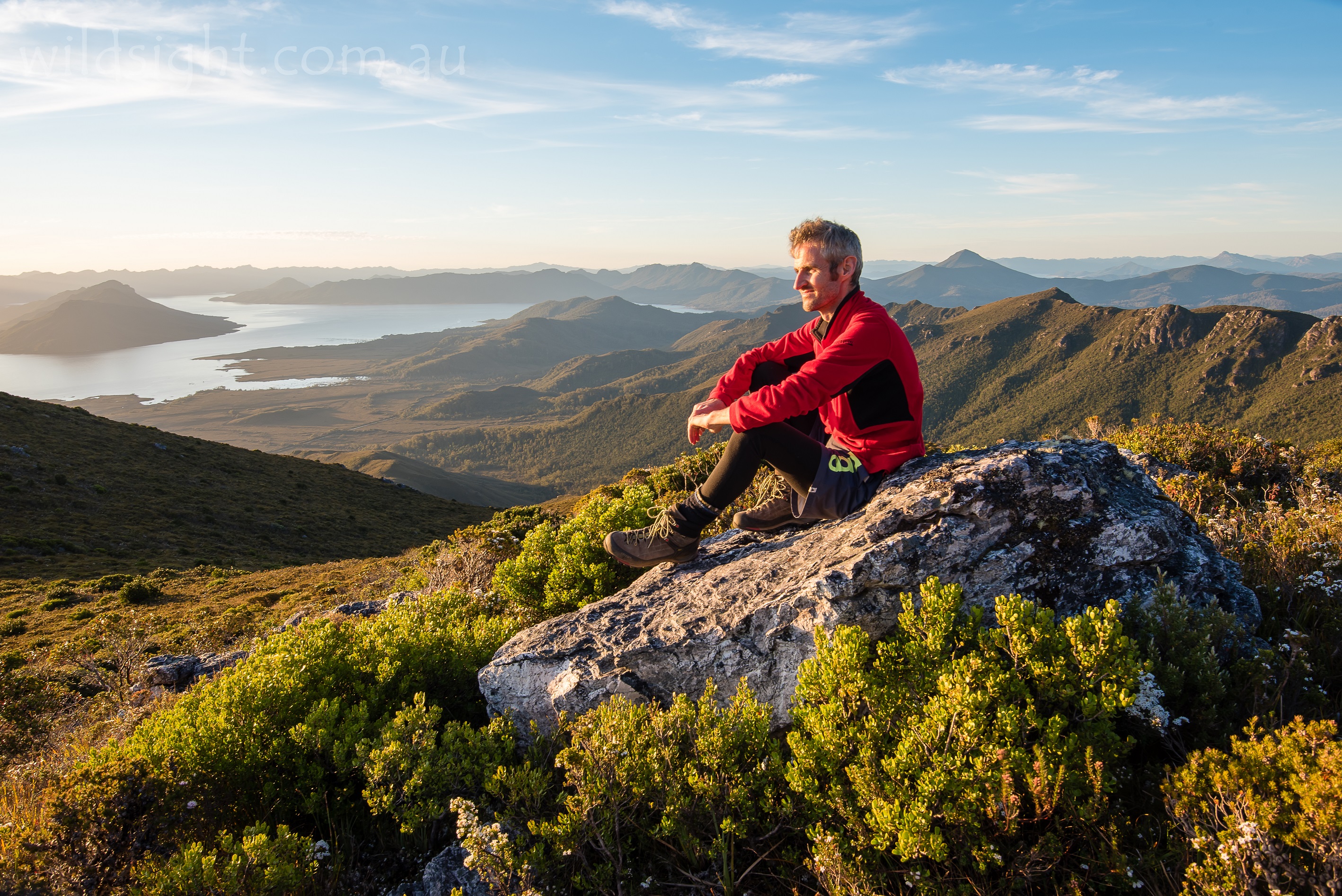
After replenishing some energy the next goal is to reach the top of the Eliza Plateau – less than 500 metres away horizontally but almost 300 metres vertically. Most of that is attained by climbing and scrambling over giant boulders, with rock cairns marking the safest route. Some sections feel very exposed especially with a heavy pack on your back, so take care. Towards the top the route returns to something that resembles a walking track before arriving abruptly at the top of the plateau – the highest point, Mount Eliza (1289 metres) is just a few steps off the path and provides a 360-degree view over the south-west wilderness. On a clear day the jagged peaks of the Western Arthur Range stretch across the horizon, with Federation Peak providing an exclamation park to the south.

From here the Mount Anne track heads north and the next 2km are very enjoyable. The route is mostly flat and meanders across the Eliza Plateau with great views in all directions. The plateau itself is dotted with picturesque tarns, alpine wildflowers and iconic Tasmanian cushion plants and pandanis.

The easy walking doesn’t last – another boulder field has to be negotiated (at least this one isn’t too steep) before arriving at a large cairn that marks a track junction. The path ahead leads to the Mount Anne summit (this will be explored tomorrow) and the track to the right descends on a rough path to Shelf Camp. Follow the latter to reach a large flat(ish) stone platform with some small areas of boggy ground where you can sink a tent peg into beside a small tarn.

Day 2: Shelf Camp to High Camp Hut
(7km, 6 hours)
After soaking in what is hopefully a clear sunrise and one of Australia’s best breakfast spots, pack up camp and head back up the slope to the Mount Anne track junction. Leaving heavy packs at the junction, pack a drink bottle, snacks and a camera and follow the clear track north towards the imposing Mount Anne summit. Note that the path to the summit is extremely exposed and should not be attempted if the weather is bad or you aren’t comfortable with heights.

The path to the summit crosses another boulder field then skirts to the right of a small knoll before crossing a narrow ridge that offers views of the spire of Lot’s Wife to the east. From here it’s boulders almost all the way to the top – follow cairns as the slope gets steeper then hits the base of a set of cliffs. This is a turnaround point for some – and still worth reaching for fantastic views over the Eliza Plateau. The summit isn’t far away but the route is up an almost vertical gully then along a narrow ledge with about 20 metres exposure – there is no shame in stopping here, especially considering another tricky climb is negotiated before hitting the summit at 1423 metres, an achievement to feel proud of.
Take extreme care descending back via the same route then return to the junction to collect packs, cross that large boulder field and head south across the plateau. If you have time it’s worth dropping packs again just past the boulders to scale the unnamed peak to the left (east) of the track. This is a much easier and less exposed scramble with views that almost match those from Mount Anne, making it a perfect substitute for those who didn’t make it to the grander summit.

The track back across the plateau offers excellent walking, a welcome reprieve before the steep descent to High Camp Hut; the boulder field is even trickier going down and some of the cairns are a lot harder to find. Don’t rush! Some walkers will want to push on to the car park but it is another good two hours of walking, stopping here is recommended to give the body a rest and make the most of another night in the wilderness – sunset views over the lake are truly spectacular.
Day 3: High Camp Hut to Condominium Creek
(3.6km, 2 hours)
It’s downhill almost all the way on day three, but the walking isn’t easy on a steep rocky track that gives the knees a real workout. It is a big relief to hit the boardwalk and traverse the last 500 metres of flat path to the car park. Don’t forget to note your return in the log book.
NEED TO KNOW
Walking in south-west Tasmania is a wonderful experience but it’s essential to be prepared – the area is notorious for terrible weather that can hit at any time, including snowstorms in summer. Carry clothing for all conditions and carrying an emergency locator beacon is another sensible precaution – they can be hired from Service Tasmania for a modest fee. Finding water isn’t usually a major issue here – carry enough to get from the walk start to High Camp Hut, where you can fill up at the water tank for the next section. Rangers advise treating or boiling water from tarns at Shelf Camp. Care is required when walking (watch for poisonous snakes as well as steep drop-offs) and when driving, the road in and out is often swarming with wildlife late in the day. No permits are required to undertake this walk but you will need a national parks pass.
The Tasmap 1:25,000 Anne map (4424) covers the entire walk.

OTHER THINGS TO SEE AND DO
Hiking is the main activity here, and most of the walks are extended – you can walk from the end of Scotts Peak Road all the way to the south coast. There is a family-friendly Creepy Crawly Nature Walk on the road not far from Condominium Creek and good camping at Eliza Dam just down the road.

ACCOMMODATION AND SUPPLIES
Maydena is the last town before heading into the wild, there are some accommodation options there and a corner store that sells emergency supplies – best to make sure you’re stocked up before leaving Hobart. There is a public toilet in Maydena with a tap that is useful for filling water bottles.

MORE INFORMATION
Vist the Tasmanian National Parks service online or phone (03) 6288 1283
These descriptions are a guide only. While we have made every effort to make them accurate, we accept no responsibility for any loss, injury or inconvenience sustained while using them. Make sure you use an up-to-date map and consult rangers before heading out.