1 day, 11km
The Castle is one of the most spectacular, challenging and rewarding day walks in Australia. It is one of the singular features of the Budawangs wilderness, where the cliff-lined plateaus and valleys that extend south from the Blue Mountains end in crumbled cliffs and a maze of rocky gullies. From a distance it’s hard to see a way to the top of the Castle, which looks a bit like a giant two-tiered cake made of solid rock. But there is a way, although it involves a lot of rock scrambling and in several points hauling yourself up a sheer slope on a rope (when we visited these were safely in place but most guides recommend taking 20 metres of rope just in case). It’s not for the faint-hearted but the reward is a grandstand view over the surrounding wild country to the coast and a well-earned sense of achievement. The walk can be completed in a very long day or you can turn it into a two-day (or more) adventure by camping at Cooyoyo Creek about 700 metres past the turnoff to the Castle. There are a large number of good campsites, plus a pit toilet, and staying here offers the opportunity to explore the spectacular surrounds (a wander in Monolith Valley is highly recommended) – but it does mean carrying a lot of extra weight up the mountain.
The Castle bushwalking track notes
The first obstacle is Yadboro River, reached 200 metres from the car park and the border between Budawang and Morton National Parks. Stones assist with the crossing but expect to get your feet wet. On the northern side of the river the track enters a surprising section of warm temperate rainforest marked by giant palms and a notable rise in humidity.

The forest dries out as the track climbs, ascending 100 metres to the top of a knoll then dropping slightly to a section of flat walking through pleasant forest – enjoy this, it’s the an easiest part of the entire hike. About 1.5km from the walk start the track hits Kalianna Ridge – the route to the base of the Castle is straight up the ridge, climbing another 200 metres in less than a kilometre on an increasingly rough trail. The final section veers to the right, bypassing the badly eroded old route straight up the hill, with some wooden steps and a small length of chain assisting in the climb to the base of the prow of the Castle massif. This is a great spot for a rest.
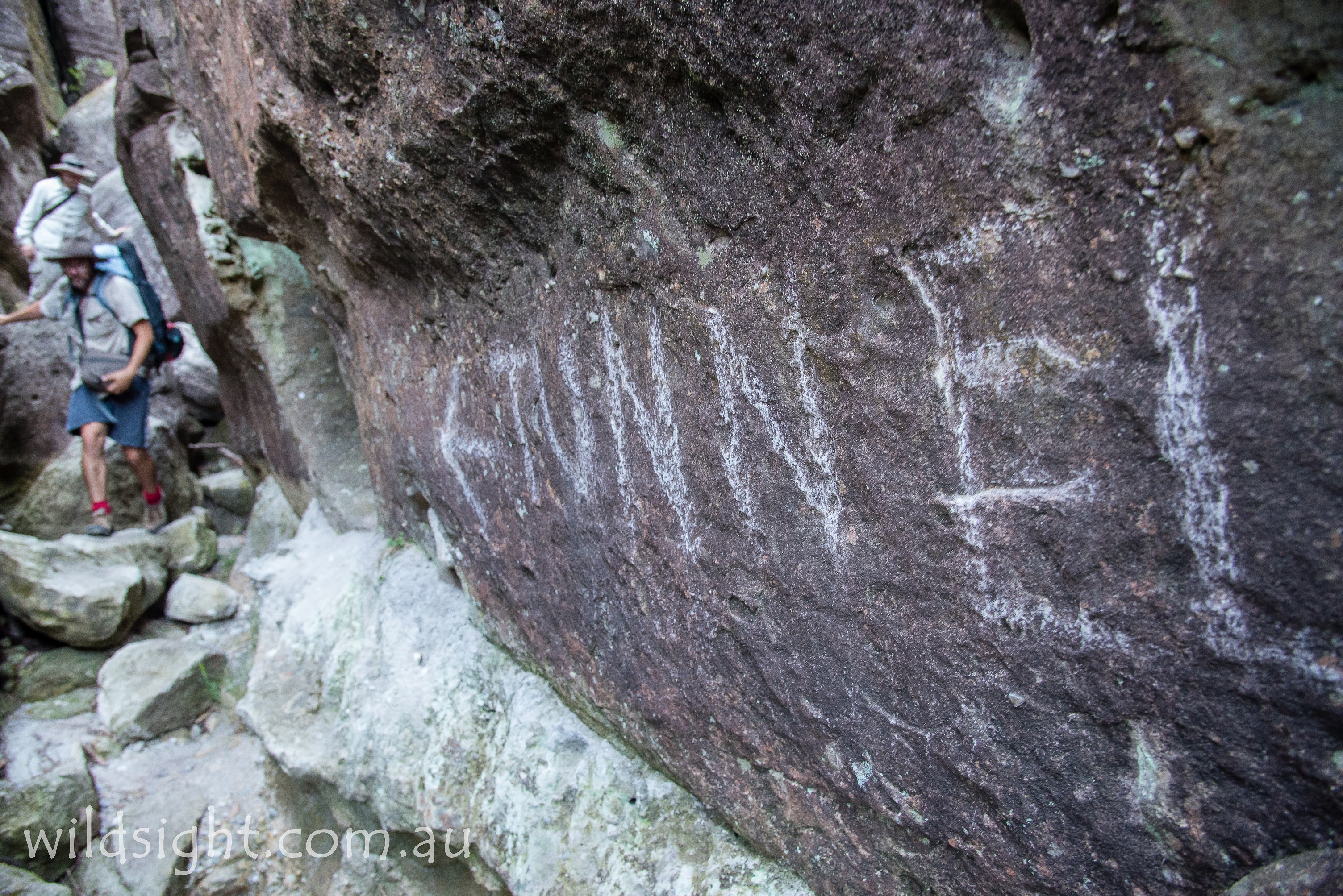
To continue, head left on a track that heads north along the base of the cliffs. At various points this involves climbing over, crawling under and squeezing between giant boulders. The track also passes beneath large overhangs and through thickets of mallee scrub. Also allow time for stopping to make sure you’re on the right track – and possibly back-tracking after taking a false trail (occasional cairns and arrows on rocks mark the way). Close to the edge of the cliffline there is a large overhang and a cave with room for three or four people to lie down – a perfect shelter if the weather turns nasty or if you’re running out of time to make it to Cooyoyo campsite (which is still another two hours away). If you’re on a day trip it’s an interesting diversion and a good spot for a snack break.

From here the route leads around the base of the cliffs then steeply uphill with the aid of some wooden steps that protect the badly eroded slope. A respite from the relentless climbing is attained at a wide junction. The track to the right heads up to the Castle. The path ahead continues to climb to a saddle between the Castle and Mt Nibelung (from here you can head down the opposite slope to Cooyoyo Creek campsite or continue north to Monolith Valley and the other peaks of the Budawangs).
Take the Castle turnoff, climbing through low scrub on a narrow track to reach a rocky gully at the base of another seemingly inpenetrable line of cliffs (the top tier of that cake). This is marked on the map as Meakins Pass, named after Reg Meakin, who was part of a CSIRO party that was the first to climb the Castle in 1948. When we visited the word “tunnel” had been helpfully scrawled on a rock at the head of the gully with an arrow pointing the way ahead – east up the gully.
After negotiating some large boulders you need to squeeze through a narrow gap then get down on hands and knees to crawl through a gap (the afore-mentioned tunnel) to a small rock ledge. There is a rope tied around a large rock to help drop to the ground a couple of metres below. You are now on the eastern side of the Castle. Turn right and head south, following the cliffs, to pick up a foot pad that leads up a slope to the first of a series of tricky obstacles that cement this walk’s iconic status. Climbing the large boulder here is not difficult but it’s a tricky step over to a second boulder that must be taken with care considering the drop below.
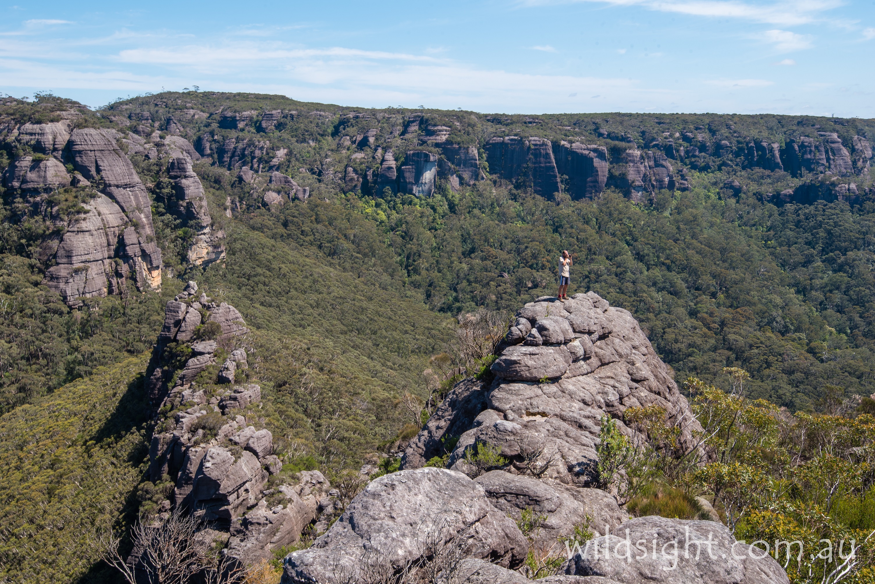
From here the path winds uphill to emerge on top of a rocky pillar, providing the first brilliant views of the hike, looking north over more pillars to the massive cliffs of Mt Nibelung, Mt Owen and Mt Mooryan. You are standing on the tail of “the tadpole”, the line of broken cliffs at the northern end of the teardrop-shaped rock massif. This is a sensational spot to enjoy a break, but the views only get better from here.
Continue south, finding a path over the rocks to the base of a slope too steep to climb – fortunately a fixed rope is in place (or at least was as of last December) to help scramble to the top. There are two more of these pitches, the next is longer and steeper – with a spectacular backdrop that makes the climb look death-defying in photos (it’s actually just very, very steep – walkers who aren’t great with heights might want to step here).
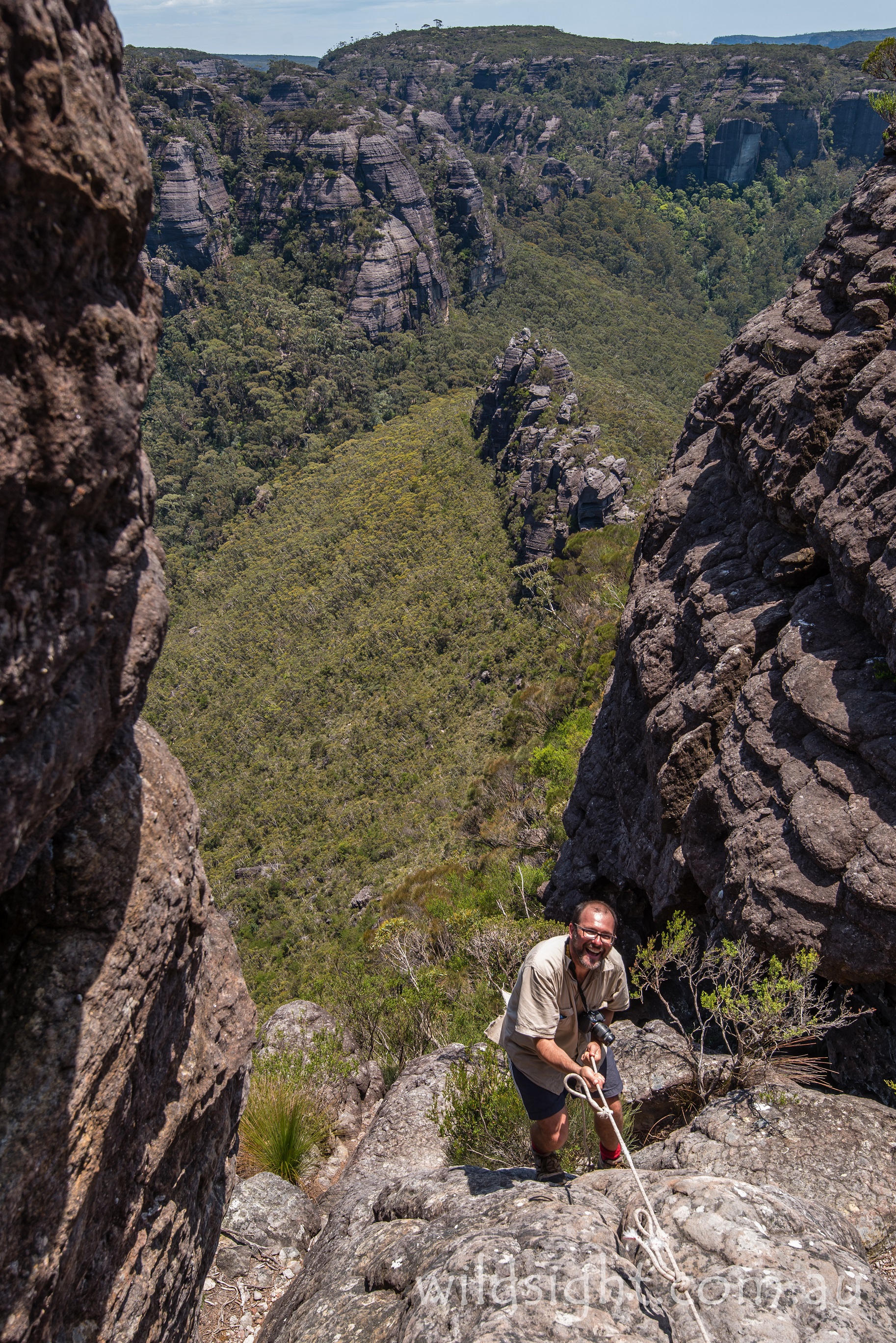
The next, and final, rope ascent is the shortest but the trickiest, heading straight up a rock chimney calling on some upper-body strength to haul yourself up through the gap. The good news is you are now at the northern end of the Castle massif. From here it’s not difficult to find a path through the scrub across the plateau – the best views are from the top of the cliffs on the eastern side, over the bulk of Byangee Mountain to the spire of Pigeon House Mountain and the Pacific Ocean beyond. Take extreme care around the cliffs, it’s a long way down.
Drink in the view and what you’ve achieved but don’t linger too long, the return route to the car park follows the same path as the ascent and several hours of walking lie ahead. The descent off the Castle and the tadpole tail is particularly tricky and the track along the cliffline presents further challenges, but at least the trail down Kalianna Ridge is a lot easier going back down. Cross the Yadboro River again to return to the car park.

NEED TO KNOW
The walk starts at Long Gully campground, 225km from Camberra (somewhat confusingly, the campground is in Budawang National Park but the Castle is in Morton National Park, in the southern region of the park known as the Budawang wilderness). Follow Kings Highway through Braidwood (home of the famous Braidwood Bakery) and take a sharp left on to the Western Distributor at Currowan. This winds north into Budawang National Park and links up with the unsealed Long Gully Road, which leads to the campground, where there is ample parking and a pit toilet. Allow four hours to complete the drive. From Sydney take the Hume Highway south and turn south on Braidwood Rd at Goulburn to connect to Kings Hwy, or head inland from Batemans Bay.
The NSW parks service introduced a series of guidelines for walking in the Budawang wilderness in 2007 including maximum group sizes (12), a ban on camping in Monolith Valley and Castle Saddle and introducing permits for camping at Cooyoyo Creek at peak times. There are also unexploded ordnances in the park, but they shouldn’t be an issue here unless you’re way off course.

OTHER THINGS TO SEE AND DO
The neighbouring Budawangs and Morton National Parks offer great wild walking and river camping. Further north there are day visitor facilities at Fitzroy Falls and Belmore Falls, but generally speaking this is an area for hardy adventurers and it is a long drive between attractions. The other main attraction close to the Castle is Mount Pigeon House (Didthul) which can be climbed in a three-hour round trip.

ACCOMMODATION AND SUPPLIES
There are several motels and self-contained accommodation at Braidwood, 28km from the Kings Highway turnoff. There isn’t much past that so make sure you’re fully stocked. There are 10 campsites at Long Gully where the walk starts.

MORE INFORMATION
See http://www.environment.nsw.gov.au/resources/parks/BudawangsBrochure.pdf for details or phone the visitor centre at Fitzroy Falls on (02) 4887 7270.
NOTE: These track notes first appeared in the September 2018 issue of Wild magazine.
These descriptions are a guide only. While we have made every effort to make them accurate, we accept no responsibility for any loss, injury or inconvenience sustained while using them. Make sure you use an up-to-date map and consult rangers before heading out.