Mount Field is home to one of the most loved and photographs natural features in Tasmania, but there is much more to the state’s first nature reserve and (with Freycinet) its first national park, in 1916. The lower part of the park is marked by beautiful rainforests and picturesque waterfalls that can be visited on well-marked trails. Follow the dirt road to the higher reaches (it takes about 20 minutes to reach Lake Dobson) and you enter a very different landscape of glacial tarns and rugged peaks. This is arguably the best spot in the state to view the famed “turning of the fagus” each autumn – when the leaves of the deciduous beech, an ancient plant with links to the supercontinent of Gondwana, turn from green to a blaze of oranges and yellows that coat the flanks of the steeper ridges and light up rocky gullies. And best of all, it’s just over an hour from Hobart.
RUSSELL FALLS (1.4km, 30 minutes)
Start/Finish: Mount Field visitor centre
This is an easy and extremely popular walk to the three-tiered falls, following a track through tree ferns and towering gum trees. The path is flat and suitable for people with limited mobility. The falls are spectacular with a good flow at any time of year but especially impressive after heavy rain – although you might get wet from the spray if you stand on the wooden bridge below the falls for too long. Visit and night and you might see glow worms near the falls.

THREE FALLS CIRCUIT (6km, 2.5 hours)
Start/Finish: Mount Field visitor centre
Add two more beautiful waterfalls linked by lush forest to make a very enjoyable circuit that is mostly easy walking with some steep sections. Follow the instructions above to Russell Falls then take the short steep climb to its delightful companion, Horseshoe Falls – stay quiet and look carefully here and you might spot a platypus in the stream below the falls.

From here the path heads west through the trees and ferns, crossing Lake Dobson Road before arriving at Lady Barron Falls, seen, as the other falls are, from an excellent viewing platform. To complete the loop follow Lady Barron Creek back east to arrive at the visitor centre.

TARN SHELF (7km, 3 hours)
Start/Finish: Lake Dobson car park
A day at Tarn Shelf will not quickly be forgotten – this is one of the best day walks in Australia. If you have the time and energy there are several options to extend the walk to a long day out, or an overnight expedition. The most popular longer route is to make a seven-hour loop by taking the Lake Webster track past Platypus Tarn and Lake Seal then climbing up onto the northern end of Tarn Shelf via Twilight Tarn and Twisted Tarn, where there are great spots to pitch a tent.

Start the shorter route described here by filling out your intentions in the log book beside Lake Dobson then following the easy track around the southern edge of the lake, following signs to the ski fields. You will soon reach a junction – turn left onto Urquhart track to head uphill away from the lake through stands of colourful snowgums and pandanis. The walking path ends at a vehicle track, take a sharp left here to head steeply uphill via several switchbacks that ascend about 200 metres to a small group of ski huts. A blue sign here has a few letters missing but points right to the Snow Gum Track – turn right here (if you miss the turnoff you’ll end up in the same place but the Snow Gum Track is more scenic).
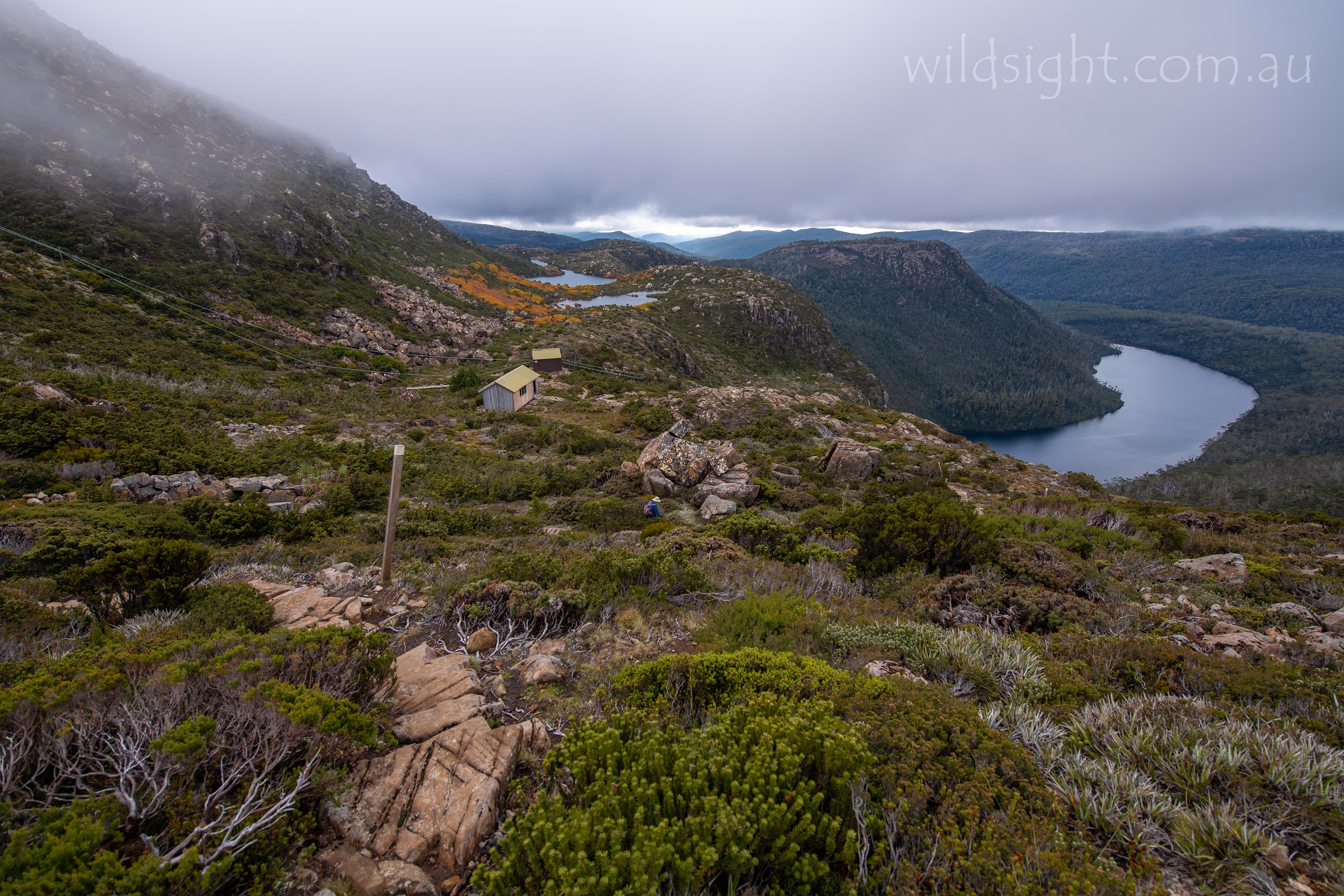
The path levels out and follows a long boardwalk with enticing views to the Tarn Shelf ahead as you approach, with a short detour to Lake Seal lookout for a view over the cliff edge to the tarns below. Reaching a track junction, turn right to descend to Rodway Hut, which has been recently refurbished and is a nice spot for a break before embarking on one of the most enjoyable stretches of walking you’ll find anywhere. The path winds gently over boulders and beside a series of delightful alpine tarns tucked underneath the steep rocky slopes of the Rodway Range – Robert Tarn, MacKenzie Tarn, Johnston Tarn, James Tarn, Backhouse Tarn and Walker Tarn, plus many more smaller unnamed lakes, some crossed by stepping stones as you head steadily north. At multiple points along the route the track flirts with the eastern edge of the plateau with grand views over Lake Seal and the distant hills to the east.
The lakes are flanked by stands of deciduous beech which are ablaze with orange, red and yellow leaves if you’re lucky enough to visit in autumn – usually in late April and early March.

After about 1.5km the path climbs slightly to the east of Lake Newdegate before rounding the northern end of the lake and reaching another junction just before Newdegate Hut – a slightly delapitaded but extremely picturesque landmark on the lake shore. This is the turnaround point for the day – if you’re taking the longer route the track descends from here to Twisted Tarn. Or, if you head in the other direction, a path climbs onto the northern end of the Rodway Range via picturesque Newdegate Pass (if you really want to make an expedition of it, the range is the gateway to the longer, remote trek to Mount Field West (about 8km away, and not for the faint-hearted).
Day walkers should retrace their steps along Tarn Shelf, enjoying a different perspective of of the tarns before reaching Rodway Hut and turning left to return to the car park via the steep vehicle track – it’s a lot quicker going down.

OTHER THINGS TO SEE AND DO
Just past Rodway Hut you’ll pass an old ski tow, a sign that this area is often under snow in winter. We wouldn’t recommend carrying skis up to the Tarn Shelf but there is a small ski field at Mount Mawson with basic facilities. There aren’t a lot of other outdoor activities here – this is a place for walking, photography and enjoying the beautiful natural surroundings.
FLORA AND FAUNA
This is a great spot to see a platypus, which live in Lake Dobson and in streams around the park. Wombats, echidnas and wallabies are also common as well as smaller and more reclusive creatures that you would be very lucky to stumble across including an eastern quoll and the eastern barred bandicoot. The park is also home to a wide variety of native birds including wedge-tailed eagles. The different ecoystems support a wide variety of plants with the fagus attracting visitors and photographers from around Tasmania and beyond for its annual autumn show.

ACCESS
Mount Field National Park is 75km from Hobart. Take the Brooker Highway (Route 1) towards Launceston then the A10 to New Norfolk. Then follow the B62 and B61 to Westerway. From there it is a short drive to the clearly marked entrance to Mt
Field National Park. The Mt Field Visitor Centre is located near the park entrance. Entry fees apply and you can
purchase Parks Passes from the Visitor Centre. Lake Dobson car park is a further 16km up a winding unsealed road.
WEATHER
Like any Tasmanian national park, the weather can be unpredictable. Bring wet weather gear at any time of year. Your best chance of sunny conditions is between January and March.

CAMPING AND ACCOMMODATION
Camping facilities are located near the park entrance on the banks of the Tyenna River – you can pitch a tent or park a caravan here. Another option is to stay in the Government Huts on the Lake Dobson Road, which provide basic accommodation with the park boundary for $45 per night – bring your own fuel stove. Phone (03) 6288 1149 to book. The nearest towns are Westerway to the east and Maydena to the west which have a small number of accommodation options.
SAFETY/WARNINGS
The park is a wild area and should be treated with respect. Some tracks are steep and strenuous and the weather can change in a heartbeat – it’s not uncommon to be caught out in a storm or even a blizzard in the middle of summer. Always carry a jacket and warm clothes, food and water and let people know where you’re going and when you get back.

TRACKS
Some routes involve rock scrambling and your feet will get muddy so sturdy hiking boots are recommended. But the tracks are mostly well maintained and easy to follow (boardwalks are provided in the most sensitive areas).
MORE INFORMATION
Tasmania Parks and Wildlife Service: Mount Field page
Or Phone: (03) 6288 1149
These descriptions are a guide only. While we have made every effort to make them accurate, we accept no responsibility for any loss, injury or inconvenience sustained while using them. Make sure you use an up-to-date map and consult rangers before heading out.